It’s monsoon and this question, ‘Will it rain today?’ will always pop in your head at least once in a day. Now, the weather forecast is not a child’s play. The agencies have to collect and analyze an enormous amount of data for hours to say a simple sentence like,
‘Probability of light shower in the evening in Delhi.’
Luckily, there’s an extremely easy way to do the forecasting by self! — By referring to the satellite images provided by IMD. Interesting right?
Weather Forecast – IRL
Forecast systems, particularly those dealing with short-term forecasts, generally use numerical weather prediction methods based on sets of mathematical equations on the behavior of the atmosphere.
These equations dealing with various atmospheric phenomena like land/ sea temperature, rain, wind etc. are combined into complex mathematical models. These models receive constant inputs on current weather observations, from which forecast data for future weather is calculated.
Although recent advances in satellite and computer technology have helped in significantly improving weather forecasting, our knowledge about the atmosphere is still incomplete and hence 100% accuracy in weather prediction is not possible.
The IMD Satellite Images
IMD – India Meteorological Department is an agency responsible for meteorological observations, weather forecasting and seismology.
We all have read in school textbooks that ISRO has launched several satellites for earth observation, remote sensing, communication etc. INSAT and Kalpana are one of them, and we’ll use them in trying to answer the pending question, Will it rain today?
Wait! But, how a normal citizen can get access to the satellite images? Well, thanks to the IMD, the satellite images are available for all. Updated in real-time.
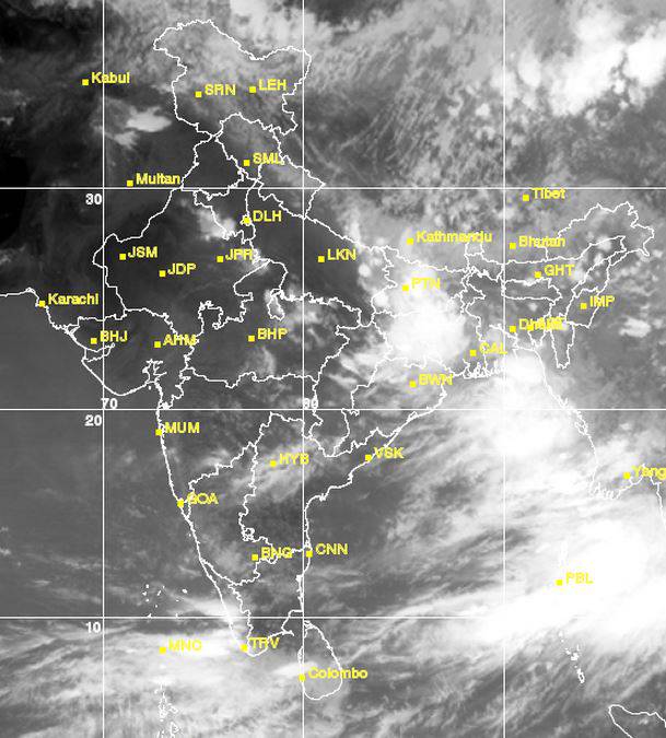
Here’s one for instance (27th June, 2015):
I live in Nadiad, near Ahmedabad (AHM in Map). There are no signs of clouds in the image above in Gujarat. The sky is spotless.
I can confidently say that there’s no chance of rain.
So…the forecasting is over! No rain today. Ditch the umbrella.
Hence, the answer to Will it rain today? is, a glance at the satellite image. For any city of India. Anytime.
Click to view the image
Click to view an animation
Listing of all satellite images
Bookmark the link, http://www.imd.gov.in/section/satmet/dynamic/insatsector-ir.htm for quick access. I am thinking about making an Android app for this. WIP.
Update:
Rahul, my friend, read this post and suggested me several ‘Desi’ methods for the rain prediction.
First is the simplest, to look at the sky and see if the stars are visible or not. I, of course, don’t need to mention what to infer when they’re visible or not.
The second is, to observe little ants. If they do not gather at the dung, it is a signal of no rain.
Farmers also use the ‘Chandra Nu Mandal’ analogy. If there are circles around the moon, it’s an indication of rain in the upcoming days.
And then there’s, ‘Jo Vadal Kare Lal, To Varsad Aave Kal.’ Intensity of red shade in the evening sky is also suggestive of rain showers.
I often read in newspapers about forecasting rain by observing eggs of a specific bird. Though, my memory betrayed me and I couldn’t recollect the exact method or the bird’s name.


Leave a Reply